Friday, September 29, 2006

Scrabble At Sea


Sailboats make many people uncomfortable. That's especially true when the boat begins to heel over. It takes a long time to become accustomed to the feeling and confident that heeling is not related to tipping over.

As an example on the other extreme is the afternoon scrabble game we had with Diane and Carmello. We were somewhere out at see off the coast of New Jersey. We had a 15-20 knot headwind. We were close hauled, and Tarwathie heeled 20-30 degrees. Once in a while, a wave or a gust would put the rail under the water. Who would believe that in those conditions that four people would be playing Scrabble in the cockpit. It was great fun.

p.s. Special thanks to my sister Nancy and her husband Karl. The gave us a Travel Scrabble set as a present. It holds the pieces securely, even in conditions like this. Posted by Picasa

Wednesday, September 27, 2006

Detour Day

La Trappe Creek, MD N 38 37.903 W 76 07.216

This is our favorite anchorage in the whole Chesapeake. La Trappe Creek is idyllic, peaceful and beautiful. This is our 4th or 5th time stopping here this year. The creek branches off the Choptank River. The famous novel Chesapeake by James Michner is about this area along the Choptank.

We traveled 35 miles today but we're only 7 miles from Saint Michaels where we started. The answer to the riddle is that we had to navigate way out around the end of long peninsula, then back again. We got here 20 minutes after sunset.

When the sun did set I tried once again to see the famous green flash. No joy, I still haven't seen it despite hundreds of tries. My friend Steve Lambert said that he once saw the green flash. He's the only one I know who did. It's a good ambition in life to see the green flash at least once before I die.

----------
radio email processed by SailMail
for information see: http://www.sailmail.com

Tuesday, September 26, 2006

Saint Michaels

Miles River Yacht Club, St. Michaels MD

We're staying as guests of the yacht club. Very nice people and a fancy place, but it's not free for visiting members of other yacht clubs. We had to pay, same as at a marina.

We biked into Saint Michaels to buy groceries today. It's nice but too touristy for us. Cambridge Maryland is our next stop, we've been there before and we know that we like it.


The picture above shows Carmello down in the engine compartement in the middle of the ocean helping me to change the alternator belt.


The picture above was taken a few weeks ago. I'll leave it as an exercise to the reader to tell where I was.

Monday, September 25, 2006

Kent Narrows

Kent Narrows, Maryland, N 38 57.762 W 76 15.189

If only every day could be like this one. The winds were just the right speed and from just the right direction. We zoomed down the bay doing 6.8 knots made good against the current, and we never heeled more than 20 degrees. There were only scattered clouds and the temperature was in the mid 70s. Ah what a glorious day.

Our target for today was Saint Michaels. We're stopped for the night 11 miles short of that goal. If we had gotten up earlier this morning we could have made it.

Kent Narrows is at the west end of the Bay Bridge that goes over to Annapolis. It is also the site of a motel where Libby and I stayed during our shopping trip to look at 14 Westsails in early 2005. I can see the motel from here.

Coming in to the Kent Narrows we had a minor emergency. The channel in here is very narrow and it is bordered by two foot depth on either side. We approached the channel under sail, and just before we got there I went to start the engine so we could drop sails. It wouldn't start. Diesel engines are not like gas engines. They don't cough and sputter. They either start or they don't. This time it wouldn't. I was completely surprised. I had run the engine some just an hour ago. It was still warm. Fortunately we hadn't entered the channel. We swung off to the side of the entrance and hastily dropped the anchor.

While anchored, I tried to diagnose the problem. It sounded like no fuel. I suspected that we ran out of fuel on the starboard tank. The piece of plastic pipe I have in there for a sight gauge is becoming opaque and stained fuel color. It looked to me like the sight gauge was full of fuel, meaning more than 10 gallons left. I suspected that instead it might be totally empty instead and sucking air into the fuel lines.

To remedy that I would have to switch to the port fuel tank, and bleed the fuel lines. I switched tanks, loosened the bleed screw, and worked the manual fuel lift pump. Fuel came out. Next step was to loosen the fuel line at one of the injecors, then work the lift pump some more. No fuel came out. That's odd. What next? I replaced the fuel filter, but when I opened the top, I could see that it was full of fuel. It had not been sucking air from an empty tank.

I worked the lift pump more. No fuel to the injector. I cranked the engine. No fuel to the injector. What the heck? Where could the fuel go? It acted like the fuel flow was cut off at the throttle. What could cut off the fuel, how about the fuel cutoff valve? I traced the fuel cutoff control cable from the lever down to the throttle on the engine. Then I lied down flat on top of the engine and got Libby to work the fuel cutoff lever in and out until I could see motion. Sure enough, the cable would pull a lever to cut off fuel, but it would not push that lever back. Somehow, the cable had become detached from the lever. I couldn't fix it very easily. To see it I need my face four inches from the throttle and with my glasses I can't focus on anything that close. I'm blind.

Anyhow, we jury rigged it. We tied a string to the cutoff lever and ran the string forward to the cabin. Now we can stop the engine by pulling on the handle in the cockpit, and we can reset the cutoff by pulling on the string in the cabin. It worked; the engine started right up and we were able to continue our passage. Next time we have a whole day down I'll see if somehow I can to a proper repair.

I'm tempted to pat ourselves on the backs for being such clever diesel mechanics. On the other hand, my common sense tells me that this engine really needs to be pulled out of the boat and overhauled. It needs a new head gasket, and it needs new studs on the exhaust manifold, and it needs a persistent fuel leak on the anti-stall device fixed. An overhaul typically takes a couple of months. We don't have a time or a place in our cruising plans to be down for a couple of months. What to do?

----------
radio email processed by SailMail
for information see: http://www.sailmail.com

Sunday, September 24, 2006

Entertainment

Turner Creek, N 39 21.919 W 79 58.754

We're sitting at anchor today awaiting more favorable winds before continuing south. Tomorrow sounds promising.

A strong cold front just passed here an hour ago. It is the same front that caused tornadoes and deaths in Tennessee and the midwest, and that threatened the entire northeast as it passed today. We had lots of warning that it was coming, so we have a secure anchorage.

I sat under the dodger and saw it approaching by eye and by radar. There was no heavy rain near us but a wall of very low black clouds approached rapidly. I estimate that it was moving at 35 miles per hour. There was only one sailboat with sails up visible when the front passed, and a couple of power boats. Simultaneous with the passage, the wind shifted within seconds from SW 4 to W 30 and light rain started.

The most drama was provided by the boat caught with its sails up. It was a little sailboat, perhaps a 21 foot day sailor with no lifelines, no roller furling. There were two people on board, although the second person apparently stayed below until it was all over. They got hit with the powerful winds from behind and promptly rounded up into the wind and dropped the mainsail. After tying down the main, I thought that they were going to sail with the jib for a while but suddenly the job sheet seemed to break away and the sail flogged violently. I watched as the captain struggled on the wildly pitching forward deck to tame that jib sail. Meanwhile the boat was lying ahull with the wind on the beam making about 3 knots toward shore. That put a definite time limit on the captain completing his task before running ashore. I ached to be there to grab the tiller for him to turn her up into the wind, but alas, he was single handing it.

Meanwhile on the VHF radio we heard someone calling repeatedly for the Boat US Tow Boat. Their radio transmission sounded very close. They called again and again but there was no reply.

Back on the day sailor, eventually the captain got the jib secured, then he disappeared below and came back a few minutes later dressed in foul weather gear.

Then we heard a new call on the radio from the Coast Guard in Baltimore. "Pan pan. Pan pan. Pan pan. This is USCG Baltimore. At 14:12 local time we received notice of a sailboat overturned in the Severn River and of a man in the water. All vessels nearby are asked to render assistance."

Meanwhile, looking behind me I could see one of the power boats that was out there at the start. It now appeared about to crash onto rocks on the shore. It appeared to be right up on the beach and two men were on the forward deck struggling with something -- I thought it was an anchor.

Meanwhile, back on the sailboat, the captain was furiously trying to start the outboard motor. He tugged wildly on the starter cord, perhaps 15 or 20 times before stopping. I think he gave up because the boat didn't seem to move.

Meanwhile, back on the power boat, I could see that the thing that the two men were struggling with was a mooring buoy and that they succeeded to moor the boat. It was just an illusion that it appeared so close to the beach.

Meanwhile, back on the sailboat, the captain had managed to deploy the anchor and now their boat sat safely with the bow up into the wind. About the same time, the front finished passing. The winds subsided to 12 knots and the rain stopped.

Back on the beach, two men got out of the power boat and motored in. Standing on the beach were two women watching anxiously. The women were not dressed right for standing out in the wind and rain. I bet they saw their men in distress looking out the window of their house and ran out.

Finally, the sail boat was able to start their motor and raise the anchor. Now for the first time, the second person appeared. Before that I thought he was alone. I could not determine the gender of the second person. Within 10 minutes they had both sails raised again and continued on their journey.

We also heard on the radio that one vessel had picked up the man in the water in the Severn River and another vessel had the overturned sailboat in tow. The Coast Guard canceled the pan pan. If you're going to capsize and get thrown in the water, the Severn River is an excellent place to do it because there are so many other boats around to assist you.

Now you see what kind of entertainment I enjoy out here on the water.

How about a safety critique of the 21 foot sail boat captain? First of all, he successfully completed all the critical maneuvers. He saved his vessel from peril. He showed courage and skill spending so much time on the forward deck of that little boat with no lifelines to hold on to. I give him a solid B for a good performance. Praise notwithstanding, what could he have done better?

1) He could have seen the front coming and been prepared. However, it came on him from behind at 35 miles per hour. Even a vigilant skipper could have been taken by surprise by that so I'm reluctant to criticise him for his failure. A better criticism was that he should not have been out there at all, given the weather forecast.

2) His best option would have been to keep sailing. Especially after his mainsail was down, the boat could have sailed nicely downwind, well under control, using only the small jib. The advantage of that choice would have been that he could have remained in the cockpit and not risked his neck by going forward. I suspect that there might have been pressure from the other crew person below decks to stop sailing that affected his judgment.

3) Having decided to not sail, he should have deployed his anchor before securing the jib, or donning foul weather gear, or starting the motor. Once anchored he could have done the other things while pointing safely into the wind. On that small boat there was no place up in the bow to stow the anchor, so it would have to have been retrieved from the cabin. Nevertheless, he made the wrong choices for the priority of his actions.

That captain's plight makes me reflect on the safety advantages we have on larger boats like Tarwathie. A sudden 30 knot wind would not threaten to capsize us even with all sails up. We have secured stowage below decks so that if we suddenly heeled 60 degrees or more, most things would not start flying around causing panic. We also have lifelines and hand holds -- very important for anyone who needs to go forward. We also have the anchor stowed in the bow ready for rapid deployment. We also have a quick starting diesel engine and a sheltered cockpit where other crew members can assist via motor without fearing for their own safety. The only counter factor is that Tarwathie is our home, not just a toy, so we are as anxious for her well being in addition to concern for our own safety.

Our first sailboat was an O'Day 19 footer and our second one was a Clipper 26, we also owned a 12 footer and a 20 foot sailboat when we lived in Sweden. A lot of what we know about sailing was learned on those little boats. Often, one has to be more skilled and more courageous to handle a little boat than a big one.

Changing the subject, now it is sunset and we just saw an enormous flock of birds. They may have been starlings. We were amazed because we could see them from 2-3 miles away and there were so many that they blackened the sky. It looked like a locust attack. The flocks divided then came together again. Finally they formed a long sinuous tear shape formation and flew away north. As the shape of the formation changed it gave it the appearance of a liquid black wave undulating as it moved northward. Great sight.

----------
radio email processed by SailMail
for information see: http://www.sailmail.com

Saturday, September 23, 2006

Georgetown

Georgetown, MD

Boy I really regret my decision to stop at the Bohemia River yesterday. We had the opportunity to sail more southward with both the wind and the current in our direction. Instead we waited until this morning and we had a fierce wind against us and the current against us too. It took four hours motoring to get 8 miles south. We aborted our plan to visit Havre de Grace because of unfavorable winds, and decided on Georgetown instead.

We rented a mooring so that we could get to use showers and laundry and I borrowed a bicycle to ride to town for some badly needed groceries.

Yesterday on the C&D canal we met a sailboat from New Zealand, and one from Canton NY. Today, at the marina I found a Westsail named Bob, also from New Zealand together with her owner Nick. Nick has been in the USA for 10 years. He bought the Westsail to sail home. He'll spend a year fixing her up and a year to sail. Nice adventure.

I wrote some stuff on safety yesterday, and wrote it poorly. Here's another attempt.

I was reflecting on how much more confident I felt sailing the Delaware on our third passage than on our first one. The first time it was daylight and I was scared. The third time I did it in the dark of a moonless night and I felt comfortable. It made we wonder if familiarity and confidence made me more safe or less safe as a solo helmsman.

Safety is a relative thing. The words safe and unsafe don't correspond to any reality. One can only be more or less safe. A number of factors contribute to safety.

Familiarity - Being familiar with the territory and the equipment saves one from having to guess. Speculation on the unknown is not always helpful.

Experience - An experienced operator has a storehouse of procedures, strategies and tactics that have worked in the past, plus knowledge of what didn't work. That breeds confidence.

Vigilance - Being constantly observant. Taking in an processing all available information.

Discipline - Having the while to adhere to known safe practices especially in the face of adverse factors including fatigue. Discipline must be soft enough to allow one to push the envelope and expand one's experience. Following prescribed and practiced procedures and having oversight by other people are key methods of maintaining discipline.

I'm sure that you could name additional factors but I think that these are the big ones. They can not be ranked in importance. A culture of safety is one in which all involved are aware of these factors and who try to apply them to their behavior all the time. These principles of operational safety are not specific to sailing. They apply equally to flying a plane, or operating the power grid, or a nuclear power plant, or performing surgery.

Based on these principles, I can critique myself. Familiarity and experience make me safer except when it lulls me into inadequate vigilance. Once, while on watch offshore late at night a Coast Guard boat pulled up behind me. They wanted to ask me a question. I'm ashamed to admit that I didn't see them approach until they were three feet away from me. My vigilance was lacking. Another time, in the Yucatan, my lack of vigilance led me to an unpleasant encounter with a fishing net. I conclude that I sometimes lack the discipline to remain vigilant when fatigued and when alone. I either need someone to oversee me, or I need to give up the helm when fatigued. That's something I have to work on. It surely helped when we had Carmello onboard because there was much less fatigue.

----------
radio email processed by SailMail
for information see: http://www.sailmail.com

Friday, September 22, 2006

Welcome Back to The Chesapeake

The Bohemia River, Maryland N 39 28.579 W 75 56.334

Last night I was on watch around midnight as we sailed up the Delaware River. I was recalling how this was the third time we have traversed these waters on Tarwathie. It felt very different the third time.

The first time through I was really scared. The Delaware River has lots of shoals and tricky currents and heavy ship traffic. The first time through we were also troubled by warnings of severe thunderstorms. Navigation is also tricky and we had no chart plotter GPS. We were heading for a marina several miles up a strange river and we didn't make it to the mouth of the river before sunset.

Last night I felt very confident. We were sailing at night instead of the day. However, I knew the route through the shoals, I knew how to time the trip to take advantage of currents and there was not much ship traffic to bother us. I felt completely relaxed. The contrast between my attitudes on the first and the third trips struck me. I was basking in the confidence of familiarity and experience, but was I less vigilant?

Thinking it through, it seems true that there are two components to operational safety -- knowledge and vigilance. Experience is valuable. One avoids confusion and errors in judgment by knowing the answers in advance. Local knowledge and familiarity with the territory is one kind of knowledge, experience with your boat and with boating is another. Vigilance can be motivated by fear of embarrassment, rivalry with peers, or by training and discipline. Being alone with nobody to see what you do is not the best way. A loner is less safe than a team. Libby helps me at critical times by questioning my actions.

Today we had a rapid trip through the C&D canal and now we're back near the Sassafras River where we sailed with David and Bobby last July. In fact, we're anchored at the same place we were last July 4. It's nice to be back in the Chesapeake and we look forward to 2-3 weeks of enjoyable times here.

Tomorrow we're going to try to visit Havre de Grace. That's a place we haven't been to before.

----------
radio email processed by SailMail
for information see: http://www.sailmail.com

Thursday, September 21, 2006

Deleware Bay

At Sea, N 39 01 w 75 02

Wednesday, September 21, 2006

I got antsy again. The optimum time to leave Cape May would have been 0400 tomorrow morning, but I got tired of waiting so here we are. The wind is against us and we'll have to do most of our cruising in the dark. What the heck, it's a very pretty day, warm and pleasant with a mild breeze. We should see lots of nice stars tonight.

This morning I worked on the engine. I tightened some connections, and measured a lot of voltages. Now the charging system is not misbehaving as it was when we were at sea. I don't know if it has anything to do with my fiddling or whether it's just mechanic's syndrome. We also changed the oil and the oil filter; one of our favorite activities. We must be getting better at it though because I didn't make a big enough mess to make it a fun story for the blog.

Last night we watched a DVD movie on the laptop. That's the first time since Marathon that we did that. It was an episode of The Sopranos. Libby and I are both big Sopranos fans. Even the theme music at the beginning of each episode is enough to give us an adrenalin rush.

We may sail all night to get to the Chesapeake tomorrow morning, or we may stop halfway tonight. It depends on whether we can keep up with the current. If one leaves Cape May just when we did, and if one can maintain 5-7 knots, one can ride the tidal swell all the 50 miles up the Deleware River and also catch the right current to pass through the C&D canal. If we're too slow though, we'll fall behind the tidal surge and the current will turn against us. It's like riding a wave on a surfboard. Either you catch the wave and surf with it or you slide down off the back of the wave.

----------
radio email processed by SailMail
for information see: http://www.sailmail.com
Wednesday, September 20, 2006

Cape May

Cape May, NJ, N 39 56.998 W 74 53.155

Wednesday, September 20, 2006

Well we dropped off Carmello and Diane this morning. I miss them already. Carmello was a very capable crewman and both Diane and Carmello were fun and made good company. I hope they have a safe trip home. They take a taxi to downtown Cape May, then a bus to Atlantic City, then a train to Groton Connecticut where they meet their so and where they left their car.

Not much to report here. We're going to sit out the Northwest winds here before heading up the Delaware Bay. Optimum time for departure is 3-4 AM or 3-4 PM. We'll see how things go tomorrow.

----------
radio email processed by SailMail
for information see: http://www.sailmail.com
Tuesday, September 19, 2006

Slow Going

At Sea, N 39 05 W 74 43

Monday September 19, 2006

Well we're still not in Cape May. All day today we had the brisk wind I asked for and we've been sailing with the rail in the water, but the wind is coming from where we want to go. We're sailing at 5 knots and tacking with 4 knots made good on starboard tack and 0 knots made good on port tack. That average to only two knots made good. It takes a mighty long time to get anywhere that way.

Now is it past sunset and the wind shifted to from the west. We are motoring and sailing with 15 miles to go to Cape May. We really want to get there tonight and get a nights sleep. Perhaps by midnight we'll be there. If so, then it will be 3.5 days total for this passage. The passage up from Cape May last summer also took us 3.5 days and I complained a lot that it was so slow.

This afternoon we had a second game of Scrabble in the cockpit. I'll post the picture of that. It was a unique experience playing Scrabble with the boat pitching and heeling that way. Windward side won the game.

Here's a guest contribution from Carmelo:

ding, ding ... ding, ding ... ding, ding ...ding, ding ... eight bells on the Tarwathie and it's my turn to collect the miles. Searching for wind, avoiding fishermen, watching for tell tale buoys we collect each precious mile one at a time. When we've collected 230 miles the game ends and Diane and I will return to our time measured world while as Dick and Libby continue their most excellent adventure. This had been a wonderful trip and Diane and I have savored every moment of it. Thanks guys, happy sailing wherever the Tarwathie takes you.

----------
radio email processed by SailMail
for information see: http://www.sailmail.com

Monday, September 18, 2006

The Jersey Shore

At Sea, N 39 53 W 73 57

Monday, September 18, 2006

We have the New Jersey Shore in sight, but not near enough to see beaches, just near enough to see distillation columns.

The second 24 hours of this voyage we only made another 65 miles, the same as the first day, we have another 65 to go to Cape May so I expect getting there about sunset tomorrow. It has been a slow passage, but the days were nice.

Everybody seems to be getting along fine, and our sleep hours are perfectly adequate. Having extra crew means also that there is more time to socialize and to chat about whatever. It's a lot more fun than cruising with two people.

A very impolite fishing vessel dropped a seine net right in front of us this afternoon. It had floating buoys and flags every 100 meters or so marking the spot. I was loathe to drive over it after my experience with the fisherman in Mexico. Our course crossed the net line at right angles. We looked off to the side with binoculars but we could only see more buoys out to the horizon. I tried several times to call the fishing vessel on the VHF to find out if we could sail across the net line. I called on channel 16 and 13 and 9 but no response. We detoured to go around the end of the net but boy was the line long. We had to go 4-5 miles to get around the end of the net line. Wow! I had no idea that they could carry nets that big. But wait, we soon ran into a second net line that also stretched out to the horizon. After following it for a mile or so and seeing no end in sight we lost patience and sailed across the line. We didn't snag anything.

What's the deal when encountering a seine net at sea? Are they all set up to be deep enough so as to not get snagged by passing vessels? There was a container ship in the neighborhood too and I'm sure he wouldn't change course to avoid the net. How many miles long can these nets be? Wouldn't you expect the people in charge of the net to monitor the VHF radio and to respond to hails? Should I have been impolite and improper on the radio calling, "I'm going to run right over this net unless I hear someone on the radio tell me not to." Do they leave them up at night? If we encountered one at night we would just cross without seeing anything.

After leaving Port Judith something has gone wrong with the battery charging. We're loosing 0.5 volts somewhere causing the batteries to not charge fully. This morning it was calm enough to lift out the cockpit floor. We did than and Carmello and I worked on changing the alternator belt (that was one suspected cause). Carmello earned his keep as crewman by laying prostrate on top of the oily motor holding a wrench to tighten the nut holding belt tension. That was the job I gave to Libby last time. My excuse for not doing that job myself is that I am too big and I can't get my legs out of the way.

----------
radio email processed by SailMail
for information see: http://www.sailmail.com

Sunday, September 17, 2006

Slow Going

At Sea, N 40 34.50 W 72 30.20

Five days ago, when we were planning this trip, the forecast called for 16 foot seas and winds 20-25 knots with gusts to 30. It hasn't been like that. Six times in the past day the winds died to zero and boat speed through the water dropped to zero also. We verified that by watching jellyfish in the water beside us. They would sit at the same place minute after minute. Libby is a real trooper though and when she has the helm she valiantly moves it back and forth and tries to adjust the sails to make us go. I have a hard time convincing her that if the boat speed is zero it doesn't matter where the tiller is.

Our progress for the first 24 hours was only 65 miles out of 220 for the voyage. Now, 30 hours in our total progress is only 83 miles. For much of the time we've been making 3 knots in 6 knots of wind or 4 knots in 9 knots of wind -- very good performance for a heavy boat but nevertheless not very exciting.

On the positive side, it is sunny and warm and the seas are flat so the boat isn't rolling around. In fact it has been downright pleasant. We staged a four player scrabble game in the cockpit this afternoon and it was great fun. We never did anything like that before while at sea. As a matter of fact, having three watches completely changed the dynamics of fatigue while sailing as hoped. That's great and I hope that we can entice more friends to sail with us on other offshore passages. I expect to sail offshore passages from Cape Fear, NC to Jacksonville FL in November and from Fort Pierce FL to Marathon in the FL Keys in December. Hint hint.

Most of the other boats we see out here are recreational sport fishermen. It must cost hundreds of dollars in fuel cost alone to roar out here 30-40 miles offshore in the morning and to return in the evening. Of course they seem never to navigate those passages at anything less than full throttle.

Carmello and Trinity (Diane) have been wonderful sailing companions. We're very glad they came. I just hope that before we get to Cape May that we get some brisk winds so that they can see what Tarwathie really can do.

----------
radio email processed by SailMail
for information see: http://www.sailmail.com

Saturday, September 16, 2006

Camello and Diane

At Sea, N 41 11 W 71 38

This is a new experience for us. We're offshore, making passage for Cape May NJ, and we have other people onboard. Carmello and Diane joined us for the passage. Carmello is an old friend from PTI days. In fact, he is still a PTI employee. They live in Scotia, and they've done inland and coastal sailing for many years, sort of like Libby and me.

Yesterday it rained the whole day. Libby and I pulled in to a marina. We did laundry, and showers, and WiFi for most of the day, then we went out to dinner at a seafood restaurant. It made a nice break from our onboard routine.

The weather forecast was for rain ending this afternoon and winds NE 20-25 with gusts at 30. When I woke up this morning, I looked out and saw bright blue sky. Uh oh. It turned into a wonderful sunny day, which is fine, but one with very little wind. Carmello and Diane arrived around noon and we left right away.

We're making very slow progress. Block Island has been in sight for the the last 6 hours, and it may be another 6 before we put it below the horizon. The wind blows a little bit, and we make three knots for a half hour or so, then the wind dies and we make only 0.5 knots for an hour.

Anyhow, it will be interesting to see how different life at sea feels with 3 watches instead of 2. There is certainly more time for conversation and that's fun.

Carmello's son Chris is learning to be an officer on a submarine. He's doing simulator training right now. That's very interesting. I wish I had more time with him to ask about his experiences with simulator training. Years ago that would have been impossible because Admiral Rickover hated simulators. The story was that a simulator was built in the early 1960s for the NS Savannah, the one and only nuclear powered merchant freighter ship. We saw the NS Savannah at anchor in the James River last summer. Anyhow, the computers in the early 1960s were inadequate for the job and the simulator was terrible. Admiral Rickover took one look at that batched job and declared dislike for computers and especially simulators forevermore. That put the Navy sub training programs behind the eight ball until the Admiral died.

----------
radio email processed by SailMail
for information see: http://www.sailmail.com

Thursday, September 14, 2006

How We Came To The Sea of Galilee.

Port Judith Pond, Rhode Island, N 41 24.291 W 71 30.346

Today we set out to go to Newport, sailing capitol of the east. (Actually one of the capitals. Annapolis, Elizabeth City, and someplace in Florida also claim to be the sailing capitol of the east.) We looked forward to seeing the sights. Our friend Andre said that there is a free dock at Fort Adams that one can use when there is no regatta. Along the way we could see the truly impressive Vanberbilt and Rockerfeller estates as well as numerous others that go way beyond ostentatious.

I was reading the guide book about Newport when we were within three miles when I came across the phrase, "Mid September Boat Show" Uh oh. A phone call to the harbor master confirmed it. This is the weekend of the famous Newport Boat Show. Newport will be mobbed with boats and crowds. We quickly changed our plans.

Instead we are in Port Judith Pond. This is close to the place where we will meet with Carmello and Diane in a couple of days to sail to Cape May. It's also a pretty nice place. At first we anchored up near the entrance between Galilee and Jerusalem Yes, those are the names of the villages on either shore. No, this pond is not really called the Sea Of Galilee, I just thought that would make a snappy blog title.

Anyhow, there is a very impressive commercial fishing fleet in Galilee. However, we decided to move up into the pond more because there was too much traffic near the entrance. In our new anchorage the scene it much more rural and peaceful. This is a very secure place to anchor.

I don't know if we'll get much chance to explore locally. We face two days of rain ahead of us. Right now it's raining and chilly; not very pleasant.

----------
radio email processed by SailMail
for information see: http://www.sailmail.com

Anchor Troubles

Sachuset RI, N 41 29.406 W 71 14.615

We had unusual troubles today. We hauled in the danforth anchor and motored away from Cuttyhunk. However, somehow the anchor got stuck on Tarwathie's bow. It had one fluke on the port side, one to starboard, and the shank was hung up on the bobstay. We had to return to the harbor, moor, lower the dinghy, and from the dinghy I was able to yank the anchor enough to free it, then raise the dinghy, cast off and sail away.

At the end of the day when we go to this cove, we tried twice to anchor with the plow, no dice. We tried twice to anchor with the danforth. No dice. We could not even get a little bite hooking the bottom. We gave up and moored to somebody's private but unoccupied mooring; something that we are usually loath to do.

----------
radio email processed by SailMail
for information see: http://www.sailmail.com

Tuesday, September 12, 2006

Cuttyhunk

Cuttyhunk Island, N 41 25.585 W 70 55.434

Yesterday we remained at anchor all day as the wind howled. Our project for the day was to work on the teak to make it look good.

Today the wind slackened some so we set sail for Cuttyhunk. That meant a relatively short sail of only 22 miles. It was a fast ride. We used only a double reefed mainsail with no jib and we still did 6 knots most of the time. There were almost no other boats out on Buzzards Bay. That was pretty remarkable considering that it was sunny and breezy and that we could see thousands of masts of moored sailboats in the harbors and coves lining the bay.

Cuttyhunk itself offers little attraction except for the opportunity to get out and walk around. Perhaps we'll do that in the morning.

I have a great suggestion for George Bush. If he wants to assure the Republicans victory in the coming election he should order restoration of the 55 mph speed limit citing energy conservation as the reason. The price of oil on the global market would halve overnight, and a few days later the price of gasoline for the American consumers would fall similarly. That is something he could do with an executive order not requiring cooperation from congress. It would be a brilliant political move.

----------
radio email processed by SailMail
for information see: http://www.sailmail.com

Sunday, September 10, 2006

Wrong. Wrong Again. It's OK

Monument Beach, Cape Cod, Mass, N 41 43.181 W 70 37.173

Sunday, September 10, 2005

I told my sister Nancy that the weather might not be nice Saturday morning, and therefore we should not go sailing with Marilyn. Wrong. It was a lovely morning. We met anyhow, onshore in downtown Marblehead for lunch and for a walk around the town. That was very nice. While we were waiting to meet Nancy, Libby and I watched the crews of two ocean racing sailboats prepare to leave. The boats were part of something called Challenge Cup 2006. There were two identical boats, both perhaps 70 feet long, both with crews of about 25 people each. All the people in the crews seemed very young, very athletic, very fit and experienced about the boat and the equipment. That must make for formidable racing. I'll post pictures.

I told the dock master that thunderstorms were forecast for Saturday afternoon. He doubted me and looked up his own forecast which said no. I was wrong. The afternoon was lovely.

We left Marblehead around 1600 and set sail for the Cape Cod canal expecting fair weather and light winds overnight. The winds were brisk. Around 2000, outside of Boston, we were hit by thunderstorms, and had to scramble to put the electronics in the oven.

The Cape Cod Canal has very strong currents, and I determined that the current would switch in our direction around noon on Sunday. I timed our departure to arrive at the canal entrance about then. Wrong. The wind was brisker than I thought, and by 2 AM we figured out that we would arrive there about 6 AM; just as the current would turn *against* us. When we figured that out, we were near Plymouth Mass (where Plymouth Rock is). I normally would not attempt to enter a strange harbor at night, but looking at the chart I could see that we could anchor just behind Duxbury Light without complicated maneuvering. We also had clear sky and a nearly full moon to light things up. So we did put in and anchor in Duxbury Bay for a little nap. That worked out well.

In the morning the weather appeared to be cold and stormy. The forecast said 20-25 knot winds with gusts to 30. In addition, our GPS went crazy. It insisted that the currents in the canal would be 25 knots! A week before and a week after it said 4 knots current, but this week 25 knots. That's crazy. Anyhow, I had visions of entering the canal with a 30 know wind behind us, the motor running and with a 25 knot current. That would have pushed us through at 40 miles per hour.

The reality was, that as we entered the canal, the current was 0.25 knots, the sun came out, and we were sheltered from the wind. With the combined effects of wind, motor and current, we traveled at 4.8 knots. A girl on roller blades on the bike path next to the canal was going faster than we were and passed us. Wrong wrong wrong.

We didn't mind being wrong so many times, we had a lovely day sailing. It was really fun watching the people on the bike path, walking, running, riding, and catching big fish. By the time we got to the end of the canal, the current picked up and we were moving 8.8 knots.

Now we're anchored in a nice sheltered little cove, just on the Buzzard's Bay side of the canal. We plan to stay here all day tomorrow, waiting out the bad weather on the fringes of hurricane Florence.

----------
radio email processed by SailMail
for information see: http://www.sailmail.com

Friday, September 08, 2006

More Marblehead

Marblehead Mass, N 42 29.887 W 70 50.834

Friday, September 8 2006

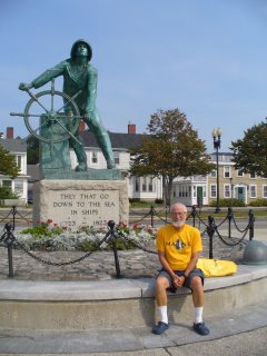
I got a picture of myself next to the Seaman's Memorial in Gloucester this morning. That statue is one of the most recognizable icons in the world. I stopped at the C of C to pick up a tourist map. The thing they were handing out is a Perfect Storm attractions map. It shows where to find the pier, the bar, the memorial, and other places around Gloucester that were seen in the movie. It's amazing what an effect a movie can have on a locality. I bet that bar sees zero fishermen and 100% tourists nowadays.

My plan was to sail to Salem today, anchor there overnight and come to Marblehead on Saturday to meet Nancy. We did that, but when we got to Salem Harbor all I could see was a big power plant, piles of coal, and lots of unattractive industrial shoreline. Yuck. We changed our minds and came to Marblehead again.

Tomorrow we meet with Nancy and Marilyn for lunch. After that we'll probably take off and head for the Cape Cod Canal. That's part of our Florence avoidance strategy. Florence will make for dangerous seas starting Sunday and lasting until the middle of next week. We plan to hide out those days in one of the several good anchorages at the north end of Buzzards Bay. To get there we have a run of 47 miles to the canal entrance and we have to time it so that we arrive at a time with favorable currents. A Sunday morning departure would be too late because we have to hit the canal between noon and 1800. We'll leave Saturday evening instead and sail overnight. I hope to arrive at the canal around noon on Sunday and we'll be at anchor in Buzzard's Bay before 1700.

Our backup plan is to stop and anchor in Plymouth Mass.

----------
radio email processed by SailMail
for information see: http://www.sailmail.com

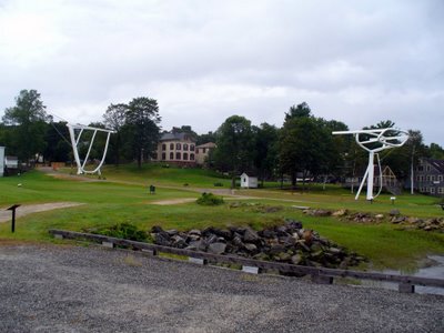
The Wyoming

This picture shows a sculpture of the sailing vessel Wyoming. The bow and stern are represented in actual size and actual position where she was built in Bath Maine. She was the largest sailing vessel ever built in America. Wow!
 Posted by Picasa

Thursday, September 07, 2006

Gloucester

Gloucester Mass, N 42 36.679 W 70 39.297

Thursday, September 7, 2006

This morning I planned to row ashore and explore the islands in the Isles of Shoals, however a nice north wind came up, and I changed my mind to take advantage of it. The north wind and pleasant temperatures made for a fine sail from the isles down to Gloucester. Gloucester is one place we didn't see on the way North so we'd like to do it today.

We entered Gloucester Harbor via the Annisquam River. In general we really like exploring rivers, but this wasn't one of the best ones. The scenery wasn't that good and the hazards were many, shoaling, foul currents, and very very narrow passages under the bridges. In this case, I wish we had sailed the long way around Cape Ann. Oh well, they can't all be winners.

Gloucester Harbor lives up to its image. It really does have a big fishing fleet. Its shores really are lined with fishery related businesses. The monument to 'Men Who Go Down To The Sea' sits prominently on the shore. It's a charming place. We didn't spot the bar that was featured in the Perfect Storm story, but my sister says that it's still here.

One sour note. We navigated to the designated anchorage area only to find it filled with moorings. Gloucester is yet another one of those places that have converted all their anchorages to moorings. This time it cost us $25 to rent a mooring in the place where we would have liked to have anchored. Grrrrr.

Tomorrow morning we'll play tourist and see what we can find downtown.

----------
radio email processed by SailMail
for information see: http://www.sailmail.com

Isles of Shoals

Isles of Shoals, New Hampshire N 42 58.758 W 70 36.793

The State of Maine is 500 feet away from us, yet already I miss it.

It took 22 hours to sail down here, with the last few hours spent motoring. The weather report was totally wrong. Neigher the forecast wind nor the forecast rain ever appeared. In fact, after midnight when we were supposed to get steady rain, the stars came out. It has been sunny all day.

We had wildlife last night. Both Libby and I saw dolphins and seals and some kind of sea bird that would fly along side us for a while and hitch a ride other times. Regrettably, we never saw puffins or whales during our Maine trip.

Now we are back at Isles of Shoals where we spent a nice with Nancy and Lena last July. This time it is very uncrowded (post Labor Day). Tomorrow morning we'll do some hiking on the island.

There is a very loud fog horn here that sounds every 30 seconds, 24x7. Instead of being annoying, we think that the sound is soothing. It is somewhat like the sound of a railroad at night, part of the normal background that noisy yet reassuring.

This afternoon I listened to President Bush's speech about terrorism and Guantanamo, and then I listened on NPR to a whole string of commentators who attacked everything he said and who reiterated what they have been saying all along totally ignoring what Bush said. I'm afraid that it's true what they say about America today. We are not only polarized, but the poles don't hear anything that the other side says. In theory, a charismatic leader could come along to help us break out of this cycle, but that's hard to imagine. What will happen to us? Will we simply degrade into ineffective impertinence as we spend our resources bickering internally? Will we find a way to effectively divide the USA into two countries, one red and the other blue?

----------
radio email processed by SailMail
for information see: http://www.sailmail.com

Tuesday, September 05, 2006

Heading South

At Sea, N 43 29 W 70 03

Tuesday, September 5

The weather forecast said that the predominant winds for the next week will be SW 5-10 knots. That sucks for someone trying to sail southwesterly. It did promise a period of 12 hours with NE winds tonight after midnight (together with steady rain) so we decided to leave Jewel Island mid afternoon and to sail overnight toward Isle of Shoals.

Now the latest weather report is saying that even in the 12 hour period, we won't have much wind. Oh well, it will be a very slow very wet trip. We want to be in Marblehead Mass on Saturday to meet with my sisters Nancy and Marilyn.

Before leaving we took another hike on the Jewel Island trails. It is a very nice island. The shades of green in the forest and moss are lovely. We saw lookout towers and gun en placements that were manned in 1944 to watch for German U boats. I must admit that Jewel Island is very nice. Valcour Island is nicer but not by much.,

----------
radio email processed by SailMail
for information see: http://www.sailmail.com

Monday, September 04, 2006

Jewel Island

Jewel Island, Maine N 43 41.332 W 70 05.383

Jewel Island is part of a Maine State Park near Portland. We sailed here today from Bath. It was an interesting day. Coming out of the Kenebec River we encountered the classic hazard. The tide was running out full and the wind was blowing the other way. In those conditions, where the river meets the sea one gets very wild and very steep waves. We sure did. For a moment I though I would be seasick.

Sailing across Casco Bay one can nearly always see submerged rocks with spectacular waves breaking on them. Even today when the ocean swells were only 2-3 feet, the breaking waves were quite a sight. Imagine what it must look like when it's really right. Believe me, breaking waves is one thing that really gets a sailor's attention. You can bet that I kept an eagle eye on the charts and on the GPS the whole way. No nap for me today.

We came here because the cruising guide says that Jewel Island is a real Jewel. The guide was right. This is a very pretty place. We rowed ashore and hiked to the the windward side of the island to watch the breaking waves. We saw three deer feeding down near the beach. We met the caretaker of the island, a young man named Vinnie. Vinnie gave us a brochure where I learned that Jewel Island is named after Mr. Jewel who bought it from the Indians in 1636 for a bottle of rum. He planned to make the island a base for fishing. Unfortunately Mr. Jewel died a few days later when he fell into Boston Harbor and drowned after a night of debauchery. I like that word debauchery. Too bad they don't use it any more. "Hey Libby, how about a little debauchery tonight?"

----------
radio email processed by SailMail
for information see: http://www.sailmail.com

Sunday, September 03, 2006

Maine Maritime Museum

Bath, N 43 53.710 W 69 48.818

Today was museum day. We got a good deal from the nice people there. Instead of ten dollars each for admission, we paid thirty dollars for a mooring that included two admissions plus hot showers and a free laundry. Such luxury cruisers can not resist.

This museum was recommended by Pete Lemme and Pete always gives good advice. Bath was the site of more than 40 shipyards in the 19th century and the museum stands on the site of one of the largest ones.

The most impressive thing by far in the museum is a sculpture. It is sort of surreal and sort of life-like. The sculpture in in two pieces. One piece is an outline of the bow and bowsprit of the schooner Wyoming. The other piece is an outline of the stern. Both pieces sit on the shipyard grounds precisely where she was built in 1908. The huge gap of open air between the two pieces conveys the immense size of this ship. It was mightily impressive. I backed off 300 yards to get a picture of the sculpture, but it still wouldn't fit in the image on my camera. I had to back off even more and move to an oblique angle to get a picture. I'll post it to the blog when I can. That was one of the most effective works of art I've ever seen. The museum plans to finish it, with more outlines of the skeleton of the keel and ribs plus the six masts. That will no doubt be quite a work of art too but I can't help wondering if it might become less effective as it becomes more explicit.

We followed the guided tour and learned a lot about the life and the methods used in the shipyard. Wow. They sure had impressive technology back then. They also had to have numerous skills to build the ship and to outfit her with sails and rigging and furniture and living implements. It is sad to think that today we have not only lost the skills of those ship wrights, but we also don't have the enormous trees in sufficient quantity to build another ship like that today.

We also went aboard the Sherman Zwicker. She is a Grand Banks fishing schooner built in 1942 -- one of the last of that type. Now she is retired and tied up at the dock of the Maritime Museum every summer. Using the critical eye of the newly informed I used my knowledge of the problem of hogging in wooden ships to look critically at her. You see, wooden ships had almost all their buoyancy midship. After some time, the ship droops down in the bow and stern and rises in the middle. Sure enough, the lines of Sherman Zwicker were spoiled. She was hogged. I'll post a picture. According to the museum guide, the useful life of most large wooden ships was only 13 years, numerous exceptions notwithstanding. It was hogging, not worms that did them in.

I also learned that the USS Constitution was hogged. To restore her, they put her on a bed of sand, and year by year they dug a little sand out from under midships. She eventually warped back to her original lines. Since she sits in the water on display, she will get hogged again and a second restoration will be needed.

All in all it was a very enjoyable day. Thank you Pete for the suggestion.

p.s. It is now 1800. The museum is closed and all the tourists are gone. There are no other boats here on the moorings. Libby and I just went ashore to take a long, hot, luxurious shower using unlimited time and hot water. That is a nearly sinful indulgence for cruising sailors.

----------
radio email processed by SailMail
for information see: http://www.sailmail.com

Saturday, September 02, 2006

Townsend Gut

Bath Maine, N 43 54.194 W 69 48.299

Well today we really had fun. We wanted to sail from Boothbay to Bath. The main route would be to sail out the bay to the open sea, then down to the mouth of the Kenebec River, then up the river to Bath.

Instead we took and inland route that wound around a very circuitous serpentine route among the islands and the rivers. The first thing we saw was Townsend Gut as a way to leave Boothbay Harbor. The Gut is like a little river about a mile long. It was absolutely charming with cute cottages lining the shores, thousands of brightly colored lobster pot buoys, and numerous lobster boats checking their pots. It would be hard to think of a more picturesque scene.

Around noon we stopped at Robinhood Marina to buy some fuel. We used 19 gallons since the last time we fueled 31 days ago.
The marina is described in the cruising guide as a place where sailors think they have died and gone to heaven. Sure enough it looked like a very pleasant place to stay. We were also treated by the sight of another Westsail 32 on one of Robinhood's moorings. The owner, Richard, was on board and we chatted a bit. Richard hauled his Westsail here from Alabama on a truck and he's been sailing Maine ever since. Richard is planning to live aboard his boat up here throughout the winter. Brrrrr. That's sure a different vision of adventure than we have.

The final leg of the the trip was up the Sasanona River. It was a lot more adventurous than our norm. When one is sailing on one's home, one tends to become somewhat risk adverse. The Sasanona River had three risks to it. First, there is a place called Hell's Gate (yes, the same name as the one in New York) where the chart says that it is only three feet deep. But the gas jockey at the marina said we could get through there. Second, the currents are reported to be fierce -- 6 knots or more. Third there is a bridge at the end of the river with a 51 foot clearance at high tide. Tarwathie needs about 53 feet clearance counting the Windex and the lightning rod on top. Never before have we tried to pass under a bridge less than 55 feet clearance.

I figured that we could clear under the bridge at low tide. The trouble with that was that we would have to fight the current and Hell's Gate against nearly peak current flowing against us. What the heck. It was a nice day and the beauty around us was too much to miss. All the way up the Sasanona River we kept passing a lobster boat with a father and two sons working the traps. We would pass him pulling up the traps, then they would pass us by, and we would pass them again. We got a good view of their catch and it was pretty good. They seemed to get one to three keeper size lobsters from each trap.

At Hell's Gate we found the depth to be OK (the chart was wrong), but the river was pinched between two rocks at one place to only about 30 foot width. For a while we were making zero net speed against the current. At the same time steering was precarious because we were buffeted by the currents. I put on a little bit more throttle and we finally passed the bottleneck at 0.25 knots net speed. Thirty minuted later we were at the bridge. I could see five feet of wet concrete sticking out at the bridge footings. That means that actual clearance should have been 56 feet. Nevertheless I crept up on it as slowly as we could possibly go. Looking up, it seemed that our mast was four feet higher than the bridge. I had my hand on the throttle prepared for instant reverse if we hit. But it went OK. When under the middle of the bridge I estimate that we had three feet clearance over the Windex. It is the illusion of false depth perception that is so terribly frightening passing under bridges.

Now we are at anchor across the river from Bath Iron Works. There are four or five Ageis class destroyers being worked on here. Just down the river is Main Maritime Museum which is our goal for tomorrow. Our fiend Pete Lemme said that it is a really great museum.

p.s. We had a hard time raising the anchor this morning in Boothbay. When it came up it brought a ball of ropes, two of which were really taught. We must have hooked a couple of lobster pots or else a big ball of lobster pot debris from the bottom. I worked for a long time trying to free the lines from the anchor but it was impossible. I had to cut the lines. That made me feel guilty because it could have cost some fisherman a lot of money. On the other hand, if they insist on planing pots in the middle of marked channels and designated anchorage areas what should they expect?

----------
radio email processed by SailMail
for information see: http://www.sailmail.com

Friday, September 01, 2006

Boothbay Yet Again

Boothbay ME Public Library

Thank goodness for insurance. The final bill for the lightning damage was about $8,000! Everthing works again and we have new updated equipment. The Rockland vendor, Ocean Pursuits, did a very professional job. The only thing remining for me to do is to install a new copper foil ground plane.

I bought the ground plane foil at Harrison Marine in Rockland. Their price was less than 1/3 of West Marine's price for the same stuff.

Yesterday we have a very nice sail from Rockland down to Boothbay. Maine continues to be very beautiful and the temperature, about 60F, is much nicer than down south.

We're in the Boothbay library today using their WiFi to apply for Social Security benefits for both me and Libby. Fortunately, some reasonalbe web applications take the edge off the irritation of dealing with the government.