Friday, August 31, 2012

Rattled

South Burlington, Vermont 

We slept at Jen's house last night, but this morning we went back to Shelburne Bay to check on the boat.  Horrors! She dragged overnight, even with Bessie our 80 pound fishermans anchor.  The GPS said that we dragged only 50 feet, but it looked like more than 200 feet to me.  (When we raised Bessie however, she had dug in deep, so she would not have dragged any more. )

I guess that I must rate that anchorage by Allen's Hill as poor holding.  We tried it twice and dragged both times, and with two different anchors. 

So what to do? Some of those nasty severe thunderstorms are on the way here today.  Luckily, the harbor master Dan told us that we could use a mooring that happened to be vacant this year. So we move to the mooring this morning, so Tarwathie  is secure.   Thank you very much Dan.  We also met another sailor this morning who told us a harrowing story about tearing his thumb off while sailing in the Bahamas.  He was lucky enough to get flown to Miami where they sewed it back on.  Today he has almost full function.  Whew. 

Wannabe cruisers take note.  When you are enjoying yourself on shore, there is always a nagging doubt as to how secure your boat (your home) is with you away.  Big boats have enough crew to leave an anchor watch crew on board.   Marinas make you feel secure, and in most cases they are secure, but they ruin your budget.  If we stayed in marinas all the time, it would use about 100% of our income. 

Thursday, August 30, 2012

Stop Whining Already

South Burlington, Vermont

Several times this summer I whined about not having clear views of the mountains from the lake.   Well, now I'll have to shut up because yesterday and today the air is marvelously clear.  We could see the mountains just fine.

By the way, my definition of clear is that we can see the colors of the trees on the mountain slopes 30 miles away,   At midday, we could see both the eastern slopes of the Green Mountains and the western slopes do The Adirondack Mountains.  God it was great.

We took a very leisurely sail from Valcour down to the southern end of Shelburne Bay.  I say leisurely, because our speed was only 2.5 knots.  It was a great day.  

Shelburne Bay is the site of our famous rainbow picture.   This time however we sailed all the way down to the bottom of the bay to a place we haven't been to in many years.  The last time there, our anchor dragged in the middle of the night and we had a hard time finding an alternate place to anchor secure from a strong south wind. It was not a pleasant memory.

This time it was much nicer.  In the first place, we now have Bessie so we are not worried about dragging.  In the second place, I met the harbor master of the nearby Shelburne mooring field.  Would you believe he reads this blog.  Anyhow, he was very nice.  Third, I sat in the suspended chair and watched the Wednesday sailboat races of the Shelburne Yacht Club.  That was great fun.  Come to think of it, the past three times I watched sailboats race were in Shelburne Bay.

Big family weekend coming up.  Coming to Jenny's house will by our son John, granddaughters Katelyn and Victoria, my sister Nancy, our niece Élan, and guests Natalie and Max.  They all want to go sailing.

Wednesday, August 29, 2012

Speciation

En route, Lake Champlain
44 29.87 N 073 19.50 W


We were asked if we have seen evidence of global warming while cruising the past seven years. We say no. Distinguishing weather from climate is very hard. If you can do it at all, it is best done from a fixed location you've lived all your life. We can however, see evidence of Darwinism as we travel.


The evidence I speak of has to do with the differences in dolphins, flies and mosquitoes we see up and down the coast.


We see dolphins almost everywhere we sail except on Lake Champlain. We see them in salt water and fresh water. The biggest pod of dolphins (~300) I remember seeing was near Cape Charles at the mouth of the Chesapeake. Very noticeable is the gradual change in size and shape of the dolphins as we move north ans south. They are biggest in southern waters. I estimate that Florida dolphins are about three times heavier than Maine dolphins.


Mosquitoes too vary greatly from one place to another. They vary in size, in speed, in voraciousness, in determination to find their way inside, and in their skill at avoiding being killed. It starts with the notorious no-see-ems in Florida. They are small enough to go through most screens and too small to see for swatting purposes. Technically, they aren't mosquitoes at all.


Of course, the worst mosquitoes are the ones most successful in biting us. I hate it when I swat 10 of them and find that 8 of the, are already engorged with my blood.


We are bothered by flies less often than mosquitoes, but when they do it is worse. Fly bites hurt. Flies draw blood like mosquitoes. Some flies are so wary and so fast that they are very hard to kill. The worst flies ever we encountered on the ICW in Georgia in the month of May. They came by the hundreds. 

If we must have flies and mosquitoes, why can't they all be big, fat, slow, and not hungry.  
Anyhow, these obvious variations in species characteristics are similar to those that Darwin himself noticed in The Galapagos. Changes are gradual. Interbreeding with neighbors prevents drastic step changes. Over great distances over a great time, drift in the genes can give rise to an entirely new species. Cool.

Tuesday, August 28, 2012

Soaring In Vermont

Valcour Island
44 36.26 N 073 25.34 W

A reader commented on this picture I posted a few weeks ago.  He said that the clouds look lenticular, and he asked about soaring in Vermont.  That type of clouds signals particularly great weather for soaring.

 
Yes there is soaring in Vermont and 20 years ago I was doing it.  The best soaring in Vermont is in the central valley east of the Green Mountains. Especially  fun is ridge soaring, where you place your wing tip 6 feet from the tree tops on the windward side of a ridge, then you just follow the contours. 

A special treat comes in the fall when mountain waves develop in the air.  Once I rode a wave behind Mount Mansfield up to 14000 feet.  Up there the wind speed matched my airspeed and I was motionless with respect to the ground.  It was also nearly soundless. It was like having an easy chair in the sky. I could see west as far as Toronto, east as far as Mount Washington in New Hampshire.  It was magic. 

Soaring was expensive for me.  Also, I'm not a natural pilot. I need to fly twice per week or else the skills atrophy.  When we moved away from Vermont, I had to give up flying. 

P.S. My camera has been stamping my pictures with the wrong dates. I'll turn stamping off. 

Monday, August 27, 2012

Reminders

South Burlington, Vermont

We've been at Jenny's house for four days. Today we return to the boat. The past 24 hours I monitored closely the weather in Marathon, down in the keys.  I worried about our friends there.   Based on what I saw, the winds were mostly in the 20 knot range, one gust to 45 knots, it sounds like Marathon dodged the bullet.

Below are two of the things that we do to remind ourselves about important things.

  1. On our fridge/freezer we turn it all the way up when the engine is running to build up  store of cold.  We put a green marker in the latch as a reminder to turn the temperature back to normal when the engine is off.
  2. We use the wall surface at the top of the companionway ladder as a white board.  One comes face-to-face with it climbing up.  I write special reminder notes there.  In the picture it says SEA COCKs, reminding me that sea cocks are closed because we're leaving the boat.  They must be re opened when we come aboard and before we start the engine.


The problem is that these, and other methods of memory reminders, fail to work for us any more.  For example, recently when we stopped the engine, Libby removed the green marker, turned down the fridge, then put the marker back.  In her mind, the marker is where it is supposed to be all the time and its reminder function is lost.  I too fail to be reminded by reminders.

We could combat familiarity by inventing a new method of making reminders each time, bu then we would have a hard time remembering what the reminder was for.  It would be like inventing a new password for each Internet site ever time you visit it.

I think the technical answer is to make check lists for each situation and to develop a culture of using them.  We would need a large number of checklists for different functions.  I also fear making the culture overly disciplinarian by insisting on their use so often.

Saturday, August 25, 2012

Benefit Baskets

South Burlington, Vermont

Well, Libby has sold a number of her pine needle baskets.  She has also taught as many as 100 women how to do the craft.  Today, she put the two together and taught a new group of students for a fee; she's now a professional pine needle basket trainer.   She didn't pocket the money though; benefits go to the hort farm.


And here are her student's first fruits after a couple of hour's labor.

While she did that I wandered around the hort farm. What is the hort farm anyhow?  Officially called The University of Vermont Horticulture Research Center, it is a research farm.  Jenny is a volunteer for the Friends of The Hort Farm.  I wandered the fields, greenhouses and trails snapping some pictures.
 
There are lots of apple trees nearly ready for picking.  There are also vineyards with many species of grapes.  There are row after row of tree  seedlings such as the Dutch Elm disease resistant elms shown.   There are also experimental plots for organic apples.  As you can see, some apple species fare less well than others organically.  Indeed, that's the purpose of a research farm.   The red flypaper captures evidence of the species of insects buzzing around the trees.  It is all very cool and scientific.

Friday, August 24, 2012

Otter Creek Shallow Water Guide

South Burlington, Vermont

I use this blog for lots of purposes.  However, one thing I resist is trying to make it into a cruising guide.  My reason is that it seems that everyone expects cruising guides to tell first and foremost about local marinas and restaurants.  We tend to avoid both, and thus we're ignorant on those important topics.   I'll make an exception today because I've been getting lots of questions about Otter Creek.

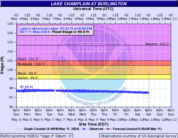
Cruising up and down the 6 miles of Otter Creek between the lake and Vergennes is one of our all time favorite things to do.  Indeed, I almost always break into song singing "Up a Lazy River."  The nature is beautiful.  The few houses and camps along the banks are quaint.  And in most years, the navigational hazards are few.  This year however, the lake level is lower than we've ever seen before.  Today it is 94.4 feet above MSL.  Most years it is 95 to 96 feet MSL, and you'll see nothing less than 8.5 feet anywhere on Otter Creek; 15 or more feet depth most places. The consequence is that there are hazards to watch out for in Otter Creek.  Unless the lake level goes up, we won't attempt it any more this year.

August 2012
August 2011, after Irene for comparison.


The pictures below highlight the hazards we have discovered.   When describing these pictures, I'll use the words left and right assuming that the boat is headed upstream.   The pictures came from our chart plotter.   You can see the latitude and longitude at the bottom left.  Ignore the other numbers. I also retouched the pictures to show shallow spots in red.

The purple lines show our most recent actual tracks.  Do not use them as a guide, actual GPS tracks vary by 50' or more day-to-day depending on how many satellites are visible above the tree line.


Above: The entrance to the creek has always been tricky, hight water or low.  The charts are incorrect showing the deep and shallow spots, you must approach and leave from one direction only, and there are no red-green buoys to help.   I saved a GPS track on my chart plotter (the blue line).  Just follow that and you'll see nothing less than 10 feet, even at a lake level of only 94 feet.

You see I went aground on the right entering the creek (AGD OTTER).   It happened on our first entrance this year.  In previous years there were two "Slow no wake" buoys right in the middle of the channel.   This year somebody (I'd like to wring his neck) decided to move them way off to the right.  I thought maybe the channel had shifted after Irene and head for a buoy that took us right to a mud bank.  Just follow the blue line.  The deeopest water is on the left close to shore.


Above:  There is a rock shelf we ran aground on this year when Libby ignored the depth alarm.  The shelf is on the left.  Just stay in the center and go slow.


Above: Everyone warns about shoaling where Dead Creek intersects Otter Creek.  They tell you to keep left.  This year, we've seen no evidence of that shoaling left, right or center.  Still, better safe than sorry.


Above:  There's a rock dead center in the channel.  We bumped it even when lake levels were 2 feet higher than today.  Someone said it is a concrete remains of a bridge abutment.  Anyhow, stay to your right for about 100 yards, stay centered before and after.


Above: For the last 200 yards before the public docks the deepest waster is on the left side.  This week we came up the creek with the depth alarm set at 7 feet.  It never alarmed once.  When exiting a couple of days later we had to plow through mud for 100 feet on the center line.  I should have stayed left (right when exiting).  

At Vergennes, the public docks are on both sides of the creek.  Both sides have free power and water.   The deepest water is on the left.  On the right side docks, it is too shallow for sailboats except at the furthest upstream spot on the right (watch out for the tree overhead).  Sailboats should prefer the left side.   At 94.5 MSL,  the depth at the docks by the left wall were 1 inch too shallow for us.  The docks past the wall are in deeper water.

If the public docks are full, there is a private dock owned by a nice man named Matt.  With Matt's permission you can tie up there.  You can also anchor just upstream or downstream of the docks.   

Do not go more than 100' upstream of the docks; it's shallow past that line.  You can see my waypoint where we learned that the hard way in 2005 by running aground.   That one was funny in retrospect.   We arrived, and I gave Libby the helm while I prepared fenders and docking lines.  I expected her to hold position.  However, the beauty of the waterfalls attracted her like a magnet until bang, we grounded on rock.  Fortunately we had dead slow speed so that we could back out.


Thursday, August 23, 2012

Happy Camper

Having Jenny on board was a delight, as evidenced by Libby's jovial mood.

Libby bids goodbye to Jen after 2 days on the boat. 

Wednesday, August 22, 2012

Jen On Board

Smugglers Cove, Valcour Island

It has been a particularly busy year for Jenny. Until now, she hasn't had the time to take a day off and enjoy a sail on the lake with us. Well, now is the time.

By the way, as I write this in the middle of Valcour's forest, there is a pileated woodpecker doing his thing on a tree right in front of me.  He's huge.  He's also quite a woodworker.  The wood chips are falling like a snow shower.  Very cool.

Jen naps enroute to Valcour.

Yesterday was a beautiful day. No wind, but sunny, blue skies, very pleasant temperatures in the low 70s, and almost clear views of the mountains. We motored from Vergennes up to Burlington, picked up Jenny and head here to Valcour Island.

What a pleasure to have her on board. Last evening we took a hike along the trails to a place with a nice overlook over the lake. When it was time to return, Jenny decided to swim back to the boat, while Libby and I walked. The water is deliciously clear, clean and warm.

Today, I expect, we'll hike around the periphery of the island.

p.s. Leaving Vergennes, we encountered a spot about 1/4 mile from Vergennes where Tarwathie had to plow through mud for 100 feet.  We draw 5 to 5.5 feet.   I'm afraid that's our last trip to Vergennes this year, the water level is too low.

p.p.s. Blog readers.  If you post a question as a comment to this blog, Google does not give me your email address to reply.  If you have a question and need a reply don't use comment, send email to dickandlibbymills     @gmail.com

Tuesday, August 21, 2012

The Other View

Vergennes, VT
44 10.17 N 073 15.48 W

We meet very few cruisers on the lake.  Most of them are inhibited from coming here because they must take the mast down to get here.  We find that socially, we have much more in common with other cruisers and we find it easier to socialize with them than with the day sailors or the vacation-only cruisers.


Vergennes is the one place where we do meet other cruisers. This weekend we met three on trawlers and one former cruiser from Minnesota who uses a trailerable sailboat to go on shorter cruises around the country.   It was fun trading stories with all of them.

Usually, when we visit Vergennes, the dinghy is up on deck.  This time it is in the water so I decided to use it to get a closer look at the falls and hydro plants.   The last picture was taken from the falls  looking back at the park where Tarwathie is docked.  Sorry about the water drop on the camera lens.


Posted by Picasa

Saturday, August 18, 2012

Can There Be A Nicer Spot?

Vergennes, VT
44 10.17 N 073 15.48 W


I took this picture this morning as I sat on a park bench enjoying my morning coffee.  Tarwathie's bowsprit is just visible. What a delightful place Vergennes is.

Where else can you anchor or dock at the base of such a picturesque waterfall?   At night, the falls are illuminated by colored lights that makes them look pretty indeed.

Add to that history.  Tarwathie sits on the exact spot where Commodore MacDonough's warships were launched.  The commodore and those ships later met the British at the key American victory of the battle of Plattsburg in 1814.

Add to that the fact that Vergennes provides what Skipper Bob's guides like to call FREE DOCK, complete with electricity and water.

Add to that the elegantly beautiful Bixby library only two block away, and the village green four blocks away where we watch the summer concerts.  A block past that is the Vergennes opera house where they have actual opera as well as other thespian stuff.  

Add to that the absolutely beautiful trip up Otter creek to get here.  I've blogged about that several times.

Add to that several nice restaurants, a supermarket, laundromat, and hardware store all within walking distance.

Add to that surrounding country roads fun to hike and offering stunning scenery.

Good grief.  What's not to like.

So while on Champlain, we visit lots of places but we keep returning to our top four for repeated visits.

  1. Vergennes as I just described.
  2. Valcour Island beloved for its stunning natural beauty.
  3. Burlington, for family (Jenny lives there), plus cosmopolitan city life.  I think Burlington, San Francisco and Montreal are the three most cosmopolitan places in North America.
  4. Porter Bay for splendid isolation, views, and nature watching, and a comfortable place to wait out storms.  We sat out Irene in Porter Bay last year.  

Friday, August 17, 2012

Warning Fumbled

Vergennes, VT
44 10.17 N 073 15.48 W

Today we cruised up Otter Creek once again.  (It's one of the best places we know.)  This time I was fully vigilant.  I steered us right along the track of the deepest water I know, and diligently avoided the shallow spaces I know.  The depth alarm didn't buzz even once, despite the fact that the water level is a few inches lower than before.

As we approached the place where we ran aground last time I slowed to dead slow.   But then I spotted another sailboat coming down the creek.   I slowed even more so as to not pass him at the narrow spot.  He kept coming and to my horror he hugged his right side.   He was heading right for that rock.

I looked and saw a Canadian flag and a French name on his boat.   Should I call him on the VHF to give warning?   I hesitated because of the languate barrier.   Well, the hesitation was too long.  BANG I heard as his boat hit that rock.  I was 150 feet away and the bang sounded plenty loud to me.   His boat jerked, but then it bounced off the rock without getting stuck.

We both continued on our way.  Me feeling guilty about my failure to give warning, and him probably feeling chagrined and embarrassed and worried about the soundness of his hull.

To assuage my conscience, when we go down the creek next time, I'll throw out an empty gallon jug tied to a rock as a warning buoy for that spot.


Wednesday, August 15, 2012

Real Info

South Burlington, Vermont

I'm delighted.  I went to the Lake Champlain Echo Center yesterday.   It is basically a kid's museum, but there is a resource room.  The resource room lady, Laura, was very knowledgeable and very helpful, and she has resources and references at hand.   I learned a lot from Laura.


  • The features in the lake like Ferris Rock are bedrock, not boulders as I suspected.  That is made clear by looking at the detailed bathymetry data.  See the picture.  Laura notes that there are some basalt intrusions into the otherwise softer sandstone and limestone bedrock that might be more resistant to erosion.
    Bathymetry data showing Ferris Rock


  • Further close examination of the bathymetry and elevation data show that, contrary to my impression, the lake is not a gorge, but rather a water covered portion of the U-shaped glacial valley.  However, there's lots of faults and thrusting, making it plain that the valley predates the glaciers by a long time.
  • What is the nature of the lake's basin? Valley? Canyon?  She says there is no official word.  However --
  • Natural slippage of this 1 foot block on Valcour may be analogous to formation of the whole valley.
    • Geologists say that it does not appear to be a river valley, or a river formed canyon like the Grand Canyon.
    • It does appear to be a rift valley.  More specifically, it appears to be slippage of a block when neighboring blocks are pulled apart.   The picture below is an illustration from Valcour Island.   The slipped block in the picture is only 1 foot wide, but imagine a slipped block the size of the entire Champlain Valley.  Laura had a technical word for this that I forgot.
    • The Champlain Thrust, within the city limits of Burlington shows older rock thrust over younger rock in a fault.
    • The palisades down by Split Rock and across from Porter bay are also clearly thrust upward from a fault.
  • Laura reminded me that the western shore of the lake was once the coast of Laurentia (the pre-continent to North America) and certainly the location of kind of plate subduction that creates trenches like the Mariana Trench.   The green mountains were perhaps formed at a much later tectonic plate collision.   The region is so ancient, that most direct evidence of the history has been wiped out by repeated stretching and shrinking of the ocean floor.

    The point is that the complete answer to my questions involve a complex combination of glacial, volcanic, and fault thrust geologies.

    I can't speak for you but for me, this is fascinating information.  This region is anything but boring.

    Tuesday, August 14, 2012

    The Greener Grass

    South Burlington, Vermont

    It is an open secret that the best views of New York State's Adirondack Mountains are seen from Vermont.   Ditto, the best views of Vermont's Green Mountains are seen from the New York side of the lake.

    New York seen from the Vermont Side
    Closeup of Rattlesnake Mountain

    Vermont seen from the New York side

    More Vermont from New York
    p.s. An secret even more closely held is that the very best Vermont fall foliage is seen in the area near Williamstown, Massachusetts.   One can get shot up here for revealing that secret.


    Monday, August 13, 2012

    Counter Theory

    Burlington, Vermont
    44 28.25 N 073 12.78 W

    Mike's counter to my Ferris Rock theory continues to intrigue.  I got the note below from reader Ken.


    Dick,
    Did you know that geologists believe that Mt. Monadnock near Peterboro and Jaffrey, NH was once the second highest mountain in the world?  It was ground down. It sounds like your friend has the right idea on Ferris Rock though.
    Ken


    If I understand Mike's theory, he says that a spire in a canyon might have escaped scouring by the glaciers.  Think of the Grand Canyon with all it's internal spires.  Even if the canyon were ground down from the top, some of the deepest parts might survive unchanged.  Fascinating.  

    Here is a pictorial summary of the ideas.

    Picture a mountainous region.

    The region is covered by glaciers.

    The glaciers grind down the mountains forming a U-shaped valley or fjord.

    Next picture a region with a deep canyon and spires in the canyon.

    As before a U-shaped valley or fjord is formed but the canyon and spire survive.

    All that is interesting, but the other theory that features like Ferris Rock could be cruise-ship-sized boulders dropped off by the glacier is still viable. I'm going to research this question more deeply here in Burlington.  There is the Vermont State Geologist, the Geology Department at UVM, and the Lake Champlain Eco Center as local resources. 

    Sunday, August 12, 2012

    My Valcour Fantasy

    Smugglers Cove, Valcour Island

    Every time I walk the wooded trails on Valcour Island, I have a recurring fantasy.  This fantasy goes way back more than 30 years since I started coming here.  I fantasize that I am the owner and sole resident of this island, and that I use it to demonstrate energy self sufficiency to the world.  I would build a magnificent house using only local materials and local natural sources of energy.

    You see living comfortably on Valcour Island would take lots of energy.   The winters here are long and cold making heat the largest category of annual energy use.   Cooling in summer would the second biggest.  Transportation, the third biggest,  followed by lights and electricity for everything else.   

    To meet all those energy needs I would eschew wind or solar power.  There just isn't enough of either year round.  What Valcour does have in abundance is clean cool water from the depths of the lake, and countless downed tree trunks.   I would base my energy needs on those two sources.   In the house I would run a series of pipes that carry cool water in summer and steam in winter. Most fun of all, I would create an extensive collection of steam powered vehicles and tools.

    I visualize myself having great fun traversing the island in my steam ATV, using steam powered saws and winches to retrieve, cut and transport the trunks of downed trees.   There are so many of them, and the supply is constantly renewed, so that the supply would be endless.   The impact of my footprint on the forest would be negligible.  The fun part of my fantasy involves designing, building and using these many steam and/or electric powered machines.   Of course the largest and finest such machine would be the electric power plant.  Electricity would be plentiful on my island.  I've worked on design and operation of power plants for many years, and I'm a great admirer of such.

    To be sure, my fantasy is just a dream, lacking the practicality of a plan.  Where, for example, would I get all the iron for the pipes and boilers?   Where would I get glass for the windows, or copper for wires.   I most certainly need broadband Internet, and that certainly doesn't come from local resources.   The nice thing about dreams and fantasies is that one needn't bother with the inconvenience of reality.

    What about food?   Well, I probably could fantasize about food self sufficiency here too, but I don't,   I'm an engineer by background, not a farmer.  If Libby or Jenny could fill in the food part of a complete fantasy..

    But I wouldn't be greedy.   In my will, I would donate the island to the public as a shrine for energy self sufficiency.  An alternate ending to my fantasy would be to allow the island to become the operations center for operating the freshly combined New England and New York electric power grids.  After all, Valcour Island is not attached to the mainland of either New York or New England -- which makes it the perfect neutral ground.  The isolation of the island makes it easier to secure from terrorist attack.  In exchange for letting the grid operators use my island, I would require them to provide me with the world's best super-high speed fiber optic Internet connection.


    Saturday, August 11, 2012

    Ferris Rock Theory


    My friend and blog reader Mike sent this lucid and evocative theory about Ferris Rock. Thank you very much Mike.

    Hi Dick,

    picture a dry enviorment,millions of years ago,now picture errosion,rain,sun,water filling a canyon..or depression formed by plate movement, there stands a probably much larger ferris rock. now picture a wetter climate, much rain, the canyon fills with water and forms a huge lake,much like today.

    Then the climate changes once again...as it always does, it gets colder, the lake is now frozen and ferris rock it trapped in the ice. It gets colder still and glaciers form. A new climate cycle begins, it starts to warm melting the last ice age glaciers, as the glaciers retreat..they do indeedgrind any rock in their path and as it slides over the top of the frozen lake,it deposits a huge field of rock.

    The lake remains frozen and the glacire passes over the frozen surface as the lake which was frozen before or during the creation of the glaciers. physics state that cold goes down and because the lake was at a lower elevation it stayed frozen longer than the retreating glaciers.

    Then, the climate continues to warm, the lake also thaws, the huge field of ground up rock sinks the bottom of the lake and litters the now existing shore line. Viola, the result of more than one known climate change...perhaps next in the cycle..serously warm...ferris rock will once again look just like those pillars in Utah.

    thats my logical theory, and im stickin to it !

    Mike,
    Published with Blogger-droid v1.6.7

    Friday, August 10, 2012

    The Riddle of Ferris Rock

    Smugglers Cove, Valcour Island
    44 32.05 N 073 24.32 W

    Being on Valcour Island and walking the trails almost always leads me to wonder about the natural wonders of this area, both visible and invisible.   Today, I'm drawn to the puzzle of Ferris Rock.

    Long time blog readers may remember that Ferris Rock is a hazard that we shun.  It is a single shallow spot isolated in an otherwise deep section of the lake.  If we tried to sail over it, we would run aground.   I've complained before that no matter where we go, Ferris Rock seems to always be in front of us posing a hazard.

    But today I'm not writing about the hazard of Ferris Rock, but rather how it manages to be there.   Based on the depth soundings on the chart, is must be shaped like a nearly vertical chimney, 120 feet tall, and 300 feet wide at the top.   I try to visualize what it would look like if the water were drained from the lake and it stood alone.  I come up with a picture resembling the famous hoodoos of Bryce Canyon Utah.  

    I could wonder how a chimney like Ferris could form.  In the US West there are numerous chimney-like rock structures.  But today I'm trying to figure out how it could survive the glaciers?   It seems only reasonable that this chimney of rock would have been broken off and carried away by the mile-high glacier that covered this region.  Right?

    Ferris Rock is not unique.  On Champlain I can immediately think of several similar structures.  Colchester Reer, Appletree Shoal, Rock Dunder and Diamond Island to name a few.   I have also sailed on Lake Malaren in Sweden.  Malaren is similar in size to Champlain, and it too was under mile-high glaciers 10,000 years ago.   Malaren is full of hazards resembling Ferris Rock.  On the charts they look like hoodoos -- very tall very thin chimneys of rock standing tall.

    If my imagination is correct that these are chimneys of base rock that withstood the passage of the glaciers, then I'm stuck for an explanation.  It doesn't seem possible.

    Reluctantly, I suppose that a more likely explanation is that my imagination is wrong.   These rocks are not as tall and thin as I imagine.  They are wider than they are tall.   They could be enormous boulders left behind as the glaciers melted and receded  

    The shorelines around here are covered with small rounded rocks and small boulders that are left by melting glaciers.  I believe the technical word is moraine.    Could it be that the moraine has billions of rocks an inch or two in diameter, plus a small fraction of larger rocks a foot or two in diameter, plus a handful of truly gigantic boulders like Ferris Rock perhaps 1000 feet in diameter?  

    A geologist should be able to answer the question simply by looking at rock samples.  Are these rocks part of the local baserock, or are they alien rocks brought here from far away?

    Wednesday, August 08, 2012

    Extremes

    South Burlington, Vermont

    Sometimes I wonder if age is catching up to us rapidly.   Yesterday I did something very stupid.  That adds to a long list of stupid things I've done recently.   Today I seemingly overcame that with a move rather brilliant, if I do say so myself.

    Yesterday was my day to do the awaited toilet rebuild.  I've had the parts for two weeks, but the job needed to wait until we were anchored near a public toilet to use while ours was out of commission.  Burlington is that place.

    We have a Wilcox and Crittendon head (toilet).  It is a massive, solid bronze item known as the Caddilac of marine heads.  New ones cost more than $1000 today.  However, parts do wear out and it needs service once every year or two.  I bought an overhaul kit with all the replaceable parts.   Yesterday I set out to install them.

    The job is unpleasant and dirty.  Not only must one deal with potentially soiled parts, but the head is big, very heavy and awkward.  I'm forced to work with it in our small cabin, which means askiing Libby to leave the boat.  It is better than competing toilets though because I could flush it with clean water first, and I never have to work with black water.

    Anyhow, I took everything apart. I took the parts out on deck and cleaned off the encrusted salt and rinsed stuff in buckets of water.  Replaced the old parts with new, and put it all back together.  Wait! When I put it together, I was missing a part.  The nut which seals the stuffing box was missing.  I looked all over and can't find it.   It baffles me how I can lose things so thoroughly on a boat, but I do.

    Now what?  Without that part, the head might leak water all the time. I could order a replacement from Theoford (the new owners of Wilcox & Crittendon) but the last time I did that it cost a fortune.  They don't stock parts other than those in the overhaul kit.  If you need one, they find a craftsman.  Give him the original drawings and have him custom cast a new part from bronze.  You can guess how expensive that is.

    Not the least of my worries was what to do without a head for the weeks it takes to get the new part.

    This morning, I started fresh and I had  a g reat idea.   I would temporarily substutte for the missing nut with something extremely simple and inexpensive -- toilet bowl sealing ring wax.  See the picture.  A sealing ring costs only $1, and I needed only 5 cents worth.   Guess what.  It worked!!! Not only that, it seems to be completely drip free.  The old stuffing box with the (now missing) nut never sealed 100%, there was always a very slow drip of water.  I'm so pleased by myself.


    But wait, now I had a leak from the toilet base place.  I had installed a new paper gasket from the overhaul kit, but it leaked around the base anyhow.   I retrieved the old home-made cork gasket that I was going to throw away.  I also wiped both sides of that gasket with more of the wax from the ring.  I worked perfectly.  I'm double pleased by myself.

    So, what does it mean when one oscillates between exremes of stupidity, absent mindedness, and clarity and brilliance?   I'm afraid to ask.

    Sunday, August 05, 2012

    Birds Versus ...

    Porter Bay, Vermont
    44 13.82 N 073 20.60

    Today is a down day for us.  More of those pesky severe thunderstorms coming through.  When will I carry out my threat to stop listening to those weather forecasts?

    Yesterday we spotted two osprey in what we believe to be an eagle's nest.  Three years ago along Otter Creek, there was a man-made pole with a nesting platform on top.  It was filled with an osprey family including three young.  A quarter mile away at the top of a 150 foot tree was an eagles nest, also with young ones.  Now it appears that the osprey nest is abandoned and the eagle's nest occupied by osprey.   Osprey normally choose nesting sites closer to the water.  I wonder if this pair doesn't simply enjoy thumbing their noses at the eagles.  A few weeks back I watched an osprey violently harassing a bald eagle sitting on a branch.  I think there's bad blood between those two families.

    Last night after sunset, a school of little minnows started jumping out of the water right beside the boat.  Were they greeting the nearly full moon just rising or were they spooked by an underwater predator?    Anyhow, a flock of three gulls quickly landed and tried to make a meal of the minnows.  They weren't very skillful.  One gull caught two, and the others caught none.


    Saturday, August 04, 2012

    Mysteries Of The Deep

    Porter Bay, Vermont
    44 13.82 N 073 20.60

    I've written before about our sandbox -- the region from 25 North to 45 North within which we migrate in search of nice weather. It may surprise you to hear this, but almost all of our offshore cruising in that sandbox is in shallow waters above the continental shelf. Indeed, except for a deep trench near Miami, the continental shelf along the US East Coast is hundreds of miles wide and almost all less than 100 feet deep. As we sail offshore north and south we are almost always in 60-90 feet of water.

    Now consider Lake Champlain. Most of the lake is more than 200 feet deep. Around here it is 300-400 feet deep. Combine that with the 95 foot elevation of the surface of the lake, and you see that most of the lake bottom is not only below sea level, but it is below the continental shelf level. Underneath our keel, the sea bottom is closest to the center of the earth here on Champlain, than on any other place from Maine to Florida.

    To be sure, that trench off Miami is plenty deep, and in the Gulf of Mexico we've sailed over 12000 foot deep trenches. Still, those are not the places we do most of our cruising.

    I've often wondered why and how Champlain came to be. It is sandwiched between two ancient mountain ranges, the Adirondacks, and the Green Mountains. I understand that the difference in age of the two ranges is about one billion years. Presumably, both ranges were formed when near the edge of a tectonic plate and involved collisions or subduction with another plate. Is Champlain the remnant of such a plate boundary? Was it carved so deep by the glaciers? Which plates collided when to form the mountains? Are the two mountain ranges parts of different plates or the result of a fold in the North American plate?


    I've read three books so far on Champlain and the geology of the region and I still don't have a clear answers to those questions.

    At one point in the past, Champlain was sea bottom, part of a vast bay extending down from the Newfoundland direction. I do not know if that was because sea levels were higher or land levels were lower. At another time, Champlain was also part of a vast fresh water lake of glacial melt water. At some point in the near future, it will rise high enough to drain south into the Hudson as well as north into the Saint Lawrence.

    Friday, August 03, 2012

    The CCLI

    Vergennes, VT
    44 10.17 N 073 15.48 W

    I assume that everyone is familiar with the cost of living index, CLI.   In several cases, there are specialized CLIs for different groups that purchase differing packages of goods and services.  Why not one for cruisers?

    That is a beautiful lead-in for a well researched piece on the CCLI complete with numbers, and graphs.   Sorry to mislead you, I did no such research today.  Perhaps some other time.   Instead, I want to gripe about two major items we need for the boat that have skyrocketed.

    10 days ago, our house battery bank abruptly started behaving poorly.  When we woke up after a night at anchor, there was barely enough juice to start the engine.  I have two house batteries, and a third emergency starting battery.  The emergency one didn't work well either.  Sigh.

    After some testing with the house batteries disconnected from each other, I determined that the older of the house batteries was faulty.  It sat at 12.5 volts at no load, but put a small load of only 4 amps, the voltage dropped to 10.5.   Must be a cracked plate.  Time for a new battery.

    The last time I bought a new battery was 2010 in Marathon. I remember paying $110 for it at the NAPA store.  Imagine my shock when I found out that today's prices for the same battery ranged from $236 to $269!!  Even a Google search, which usually turns up the lowest prices anywhere didn't find anything cheaper.  Ouch.   2.27 times more expensive in less than 2 years.

    One thing that leads to reduced battery life is that our solar panel is too small to desulphate (also called equalize) the batteries every 30 days or so.  Libby and I decided that we have procrastinated enough.  I have several quotes in my bookmarks since last February, for nice panels at $1/watt.  Time to buy.  I called Sun Electric in Miami, the company that gave the favorable quotes.  I was shocked to learn that this company no longer sells panels retail, they sell only by the pallet of 20 panels.  Again a Google search of the internet showed that the retail price of solar panels has soared from $1/watt to $2.5/watt in only 7 months. WTF!!!  It must be because of that danged tariff that Congress imposed on panels imported from China. Thank you Congress.

    I'll keep looking for a panel.  My search was not exhaustive.

    ----
    Now for something completely different.  No more griping.  This is a news story I read yesterday that I must share.  It's just too too funny.  Criminals are not smart, not even white collar high finance criminals ...


    Lessons in How Not to Insider Trade

    If there’s a lesson to be learned from Thursday’s ten-page criminal complaint accusing Bristol-Meyers Squibb executive Robert Ramnarine of insider trading, it’s that Yahoo searches are no place to learn how to get away with it.

    According to the complaint, about a week before some of the alleged trading, Mr. Ramnarine opened up Yahoo on his office computer in Princeton, NJ and entered a flurry of searches, including “can option be traced to purchaser,” “can stock option be traced to purchase inside trading,” “insider trading options traceillegal [sic].”

    Thursday, August 02, 2012

    Radiolabs

    Vergennes, VT
    44 10.17 N 073 15.48 W

    A while back I wrote that there were fewer boats on the lake this year.  Well, now the Canadian vacation season is in full swing and the Quebecois are out in full force.  It makes us feel isolated.  Here in Vergennes for the third day, there have been maybe 25 other boats that came to visit.  Not one of them spoke English.

    We're hoping to see Pierre and Christina aboard "Anvil of the Sea". They are among our favorite Quebecois and their English is excellent. We've met them twice before, both times in Vergennes.

    I found Radiolabs, a radio program, new to me.  It has outstanding stories and in-depth reporting on a variety of interesting topics.  I dare say it might be the best radio program I can remember ever.  If your public radio station doesn't carry it, you can find podcasts here.   There is a long list of past episodes. For starters try this episode about time  or merely click below.

    Wednesday, August 01, 2012

    Libby's New Toy

    My computer is my main toy. Libby needs some toys too. Don't you think?
    Published with Blogger-droid v1.6.7