44 25.61 N 073 14.94 W
Last week we visited Schenectady and Rotterdam Junction. We saw some of the flood devastation. It was so sad to see mountains of people's spoiled possessions piled by the roads. However, nothing we saw first hand compares to the pictures I found later. The destruction is hard to imagine.
| Erie Lock 8, (Source The Columbia Missorian) The lock is under water between the house and the dam. |
One spot we spent a lot of time at is Erie Lock 11 in Amsterdam. We were especially fond of the Walter P Elwood museum housed in Guy Park Manor at the lock. The museum had lost its previous home. The museum is a jewel, more fun to visit than some of the Smithsonian Museums in D.C. I blogged about it here. Guy Park Manor is a wonderful mansion which has survived at that site since 1773, 3 years before the American revolution. Here is a NY Times article about the destruction. The Amsterdam Recorder also said that the water was even 5 feet deep in Russos Restaurant across the RR tracks and highway from the museum. The currents must have been very swift and powerful. Pictures below.
| Lock 11 and Guy Park Manor, (Source, Amterdam Recorder) |
| Closeup of Guy Park Manor, (Source, NY Times) |
| Amsterdam, NY, Lock 11? or Lock 10? (Source Albany Times Union) |
That big thing that looks like a bridge is actually a dam. It has steel gates that are lifted in winter to let the ice through. Those gates appear to have been destroyed.
Now, after the flood waters are gone, the river/canal has almost become a dry wash. That is because of damaged gates at the downstream dams. They lost the ability to control water levels in the River. The NY Canal corporation's first priority must be to repair the dams before next spring's thaw and flood. If they don't the ice and spring flood will damage and destroy still more. I would not be surprised if it takes more than one year to reopen the canal for boat traffic.
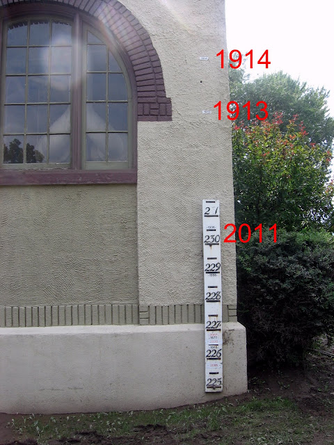
As a reminder of the importance of those dams, look at the picture below. It shows a flood gauge on the wall of a city building near the river in the Stockade section of Schenectady, NY. Marks on the gauge show the crests of various spring floods in past years. This flood in 2011 is almost of the top of the scale. However, smaller signs on the wall show the floods of 1913 and 1914 which happened before completion of the modern canal and dams in 1918.


Glad you and Libby are in good shape - what a mess - disaster for the area.
ReplyDeleteDevastating. No other word can describe what we are seeing here more succinctly. The best we can hope for is that the neighborhood has already picked up the pieces, and drained out all the water and taken out the seepage in their homes, and hopefully have restored everything to it's former glory.
ReplyDeleteGail Wallace